LAKE
BISTINEAU
(Past and
Present) the following dates and events have been noted from various books and documents
and are intended to be used for unofficial info only and to solicit related information
either confirming, contradictory, or additional. If anyone has such info
please contact Joe Hinton. E-mail address is: joehinton@bellsouth.net
Please note that I
have taken the liberty of paraphrasing the individual bits of historical data into
what I hope is a more telling manner.
Some readers have asked about "a possible contradiction" in
the Scriptures and dates included herein... As far as I am concerned, there are no
contradictions because God created everything and
questions come only when someone attempts to relate God's timeframes to man's which
is impossible to do. I do sometimes wonder if God did make some humans to believe
that they evolved from monkeys and act accordingly.
YEAR - EVENT
8500 B.C.- Initial human occupation of the Lake
Bistineau area occurred during the Late Paleo Indian Period (ca. 8500-7500 B.C.). The
Paleo Indians were the first humans to occupy North America and small groups of these
nomadic hunters-gatherers moved into the Lake Bistineau area on a seasonal basis to hunt
and gather the plentiful game that abound here. Projectile points from their hunting tools
have been discovered in NW Louisiana with one recovered from Peggy's Island in Lake
Bistineau.

7500-5000
B.C.- The Paleo Indians
sensed the environmental changes that were slowly taking place with the retreat of the
glaciers in North America and the general warming of the climate in the Lake Bistineau
area (see Climate), including major changes in the distribution
of plant and animal life(Plants) , and began to
make new adaptations and new life styles. Thus the once nomadic lifestyles evolved ever so
slowly into a more sedentary living , accompanied by development of pottery and
bow-and-arrows. Artifacts from this change in lifestyle have been found in Bayou Bodcau
and on Clarke Bayou.
5000-3000 B.C.- One of the first great technological
discoveries in history (the grinding stone) was developed by the Indians and was now being
used to grind and polish tools such as axes and for notching stones for use as "net
sinkers" and for sharpening stones into "scrapers"(crude knives). This
development greatly enhanced the Indians hunting and fishing activities. Polished points
from the hunting arrows have been found near the Louisiana Army Ammunition Plant
(LAAP).

3000-500 B.C.- The Indian population in the
area grew significantly as new and better hunting, fishing and food preparation techniques
were employed. Baked clay pots were now being used for boiling.There were several salt
licks in the area supporting considerable trade networks with surrounding nations
and items normally exotic to the Lake Bistineau area began showing up at local sites. The
Indians were now seen wearing numerous beads, pendants and other ornaments ground and
polished from stones. A red jasper owl effigy bead from this period has been found near
the ammunition plant(LAAP). Potter's Pond, located in the northern part of Lake Bistineau
was given its name from the numerous broken fragments of Indian pottery found there.
500 B.C.-A.D.900- The Caddo Indians moved into the area
bringing with them a whole new culture. widespread use of ceramics began as did garden
crops of corn, squash, gourds and beans. In 200 B .C. the Indians used
Spanish Moss for curing cancer and to prevent starvation; the Indians really had to limit
how much they ate because Spanish Moss was very hard to find, it usually took 7 - 8 hours
a day just to look for one plant. Spanish Moss was also used for dealing with problems
like hunger or starvation.

A.D. 900-1200- From the new technologies of the
Caddo Indians came development of new vessels such as the bowl and the bottle. The first
use of red pigment filler was used by the Indians to decorate the vessels.
A.D. 1200-1400- The Caddo Indian culture was now
dominant in the area.
A.D. 1400-1500- The "Great Raft" and Lake
Bistineau were formed. The Great Raft was actually a series of smaller "rafts",
or accumulations of log jams and driftwood, cemented with mud, sand, and debris, which
blocked the flow of the Red River from just above Natchitoches to almost the Arkansas
boundary. As this barrier to normal river flow grew backwaters began to overflow
creating or enlarging streams and bayous. Bayou Dorcheat, Lake Bistineau and Loggy Bayou
were formed.
1500s- First Europeans arrive in the area.
Following the discovery of the Mississippi River in 1541 by Hernando de Soto, Spanish
explorers found their way into NW Louisiana and to the Lake Bistineau area supplying the
Indians with their first guns and ammunition. The Indians supplied the Spanish explorers
with salt, horses*(See Note at end of this paragraph) and food in exchange for glass beads, kettles, guns and ammunition, and
knives. These new visitors along with their influences ( including diseases to
which the Indians lacked immunity) soon brought rapid and devastating changes to the
traditional Indian life and a severe decline in their population.
Note: It was recently brought to my attention by a good friend, Mr. Gerald
Glover, currently of Minden but a native of Claiborne parish, that it was the
Spanish who first introduced the horse to the indians. My translation of the
history between the Spanish and the Indians incorrectly implies that the Indians
traded horses to the Spanish, so I have added this note as a correction to my
error. Speaking of Mr. Glover, I would like to share this true story with all.
It took place about 1977
so I ask you to go to that date on page 2.
1600s- Flooding of the Lake Bistineau area
caused by the ever increasing overflow from the Red River caused the Indians to move their
villages north to higher ground. By the end of the 1600s the Caddo Indians had almost
exclusively vacated the area. Only one small group, known as the Yatasi, remained. The
extensive flooding also ceased all salt production in the immediate area.
In 1692 Robert Cavalier, Sieur de LaSalle claims the
Mississippi valley territory for Louis XIV of France(for whom Louisiana is Named) and
French explorers, as the Spanish explorers 150 years before, soon find their way north
into the Lake Bistineau area (see 1714)
1690- According to Sharon O Kleinpeter's History Of Bienville Parish, the
first white leader to sight Lake Bistineau was Don Domingo Teran DeRios, who was sent from
Mexico in 1690 to scout the complete Caddo Federation of Indians. Sharon also reports that
this expedetion included Father Masinettes who established a mission called "Mission
Loretteto", believed to be located near present day Ringgold, La.
1700s- As the river became increasingly
clogged by logs and debris that made up the"Great Raft", the current in Dorcheat
and Lake Bistineau became increasingly rapid due to the discharge pressure from the river
above the raft and was destined to become the principle channel of the Red River had not
the Great Raft been eventually cleared(see 1873). In other words, Lake Bistineau almost
became Red River.
It was about 1700 that a band of Choctaw Indians set up a
village just east of Bayou Dorcheat near what later became the present day Shongaloo. It
is believed the name Shongaloo came from the Choctaw name "Shakalo" meaning
cypress tree. Shongaloo also means running water and the Indian trail passing the springs
there was called "chicken-in-the-trail". The present highway coming from the
northwest and veering to the east after passing the old Shongaloo church follows the
original Indoan trail. A large Indian mound called "Wauhoo Ridge" was located
there. A skull, pipe, several tomahawks, pottery and stone implements have been recovered
from the area.
1714
- Louis Juchereau de St. Denis
established Fort St. Jean Baptiste(Natchitoches). Natchitoches ( in Indian
language;"place of the paw paw or chinquapin") was the first permanent white
settlement in the present Louisiana and the French soon expanded their explorations north
into the Lake Bistineau area. For more about Natchitoches then and now click on Natchitoches.
1787
- A Frenchman named Francious Grappe or
"Touline"*acquired land near what is now called Lake Bistineau but at that time
was called "Big Broth Lake"(Bestino) by the native Indians for it's
foaming waters.Grappe and his family came from Toulon, France and were the first white
settlers in the area. There is a stream that flows into the Lake on the east side that was
given the name of "Toulon". Indian trails discovered later in 1806
led to large cattle pens owned by Grappe located near what is now Ringgold, La. One such
trail crossed Dorcheat just where it empties into Lake Bistineau(present Sibley-Doyline
Road)proceeded south and turned to follow a path(present Lake Road) to the lower end of
the lake.
1793- The Koasati or"Coushatta"
Indians migrated to Louisiana from the Mississippi Territory.(see 1804)
1800
s- Spanish cession of Louisiana to the
French was made by a secret Treaty in 1800 and France in turn sold it to The United
States in 1803 (Louisiana Purchase), and after Major General Andrew Jackson's decisive
victory over the British at New Orleans in 1815, the controversy of domain was finally
settled, and boat traffic soon began up Red River from points south. Not only did the Lake
Bistineau and Dorcheat Bayou provide a channel for steamboats in later years, it was the
only avenue for such transportation in the entire area of Northwest Louisiana above
Campti. Campti is one of the oldest towns on the Red River. In 1827 it was known
as the outfitting point for the upper country--Claiborne and Arkansas. In1874,
every house in Campti was burned by Federal troops.
1804- Natchitoches Parish was established by
the General Assembly of the Territory. The parish includes all of Northwest Louisiana with
Natchitoches as the Parish Seat as there were no civilized settlements north of Campti at
the time.
The History of Claiborne Parish: "North louisiana, at this time was
covered with a dense mass of brush-wood and interlacing vines. The few settlers
that ventured into these wild regions had to fairly hew their way, for only a
few deviou trails and paths were to be found. But gradually, settlement followed
settlement, clearings increased, and from these clearings and the camps of the
hunters, fires broke out sweeping over the land, killing the tangled undergrowth
or brush-wood, even destroying the foliage of lofty trees."
1804- Dr. John Sibley, an Indian agent in
Natchitoches, was petitioned by 30 Koasati(Coushatta) Indians to settle in NW Louisiana
and six to eight families led by Chief Echean moved to the area around Lake
Bistineau. The main Coushatta village was located on Red River in north Bossier
Parish with smaller sites extending south of Lake Bistineau with one near what is now the
spillway on La 154. Chief Echean lived in the villages nearest the Lake.
1805-
April 10, 1805, Louisiana's New Orleans territory was subdivided into 13
counties. The largest was Natchitoches which covered all of north Louisiana. It
wasn't until 1807 that the legislature voted to divide the territory into
parishes. Administration of local policing duties were given to a jury of 12
inhabitants..thus born the Parish Police Jury.
By 1805,
the Caddo Indian population in the area
had shrunk to only twelve men and nineteen women and were located just south of Lake
Bistineau near Coushatta.
1806
- On June 2, 1806 explorers
under the leadership of Thomas Freeman and Dr. Peter Curtis set out from Natchitoches on
the Red River in two flat-bottomed barges and one perogue with an Indian Guide named
Talapoon and accompanied by M. Touline(Grappe). On June 11th they reached a place where a
bayou branched off of the river and was informed by Touline who was
familiar with the area that it was impossible to proceed up the river because of a huge
log jam(The Great Raft) that blocked the river just north of this place. So they entered
the bayou (present Loggy Bayou). About five miles up the bayou they entered "Big
Broth Lake"(Bistino), and then Bayou Datche(Dorcheat). The Indian guide Talapoon
explained;" the Indians named it "Datche"which in there language
signifies a gap eaten by a bear in a log, from circumstances of the first Indian who
passed this way, seeing a bear gnawing a log at this place" There are others who are
inclined to connect "Datche" with the name Cadodaccho, a general term for 'clan
or 'people' relating to the name of some Caddo Tribe. The French word "bayou"
came from indian word "bayuk" meaning river or creek.
News of this exploration spread and the area fast became
known throughout the country, as evidenced by this announcement...."The country
above the head of Lake Bistino, is highly spoken of, as well the highlands, as the river
bottom...on the my informant says, 500 families might be desirably settled..." (Thomas
Jefferson, U.S. President 1806)
1811- Legend has it that there was a great
earthquake in the Mississippi Valley about the year 1811 significantly increasing the area
of Lake Bistineau,(Click here to read an
interesting article published in 1939 about Lake Bistineau.) Up until the turn of the
century Bistineau was an open lake and one could stand on Yellow Bluff(?) or Pine
Bluff(near Laguna Beach) and see for miles up and down the lake with not a tree in the
lake.
The
following was taken from the above mentioned "1939 article":
"About the year 1811 all through the Mississippi Valley,
there came an earthquake. The earth rose and fell in many places where the earth sank,
natural reservoirs were formed, making ponds, streams and lakes. (sic)
Among the better known lakes thus formed is Reelfoot Lake
in Tennessee. In this case, the Mighty Mississippi River flowed backward three days and
nights, filling this depression of the earth’s surface.
An old resident of
Bienville, Parish, who is now 67 years
old, moved from the state of Alabama in an ox cart to the shores of Bistineau at the age
of seven and claims at that time, he asked Granny Richardson, who was 80 years old, how
the lake was formed and she told him that when she was a little girl behind her house,
about a mile, was a small stream of water, one that could be stepped across, and one night
the water rose, make a stream two miles wide."
The
following was taken from an Associated Press article published in the Shreveport
Times 29 Nov, '98:
"New
Madrid fault could shift in the next 40 years, according to historical evidence.
The New Madrid Seismic Zone stretches from northeastern Arkansas into southern
Illinois, and experts estimate there is a 90 percent chance of an earthquake of
magnitude 6.0 or greater by 2040.
During the
winter of 1812, three quakes destroyed the town of New Madrid, Mo., rang church
bells as far away as Boston and disrupted the flow of the Mississippi
River."
. . . . and based on events of 1939, could again change
Lake Bistineau drastically.
1811 brings
first American settlers to area. Following the Freeman/Curtis expedition and subsequent
announcement of the area by Thomas Jefferson in 1806,
immigration into Northwest Louisiana increased. In 1811 Isaac Alden traveled
up the Red River into Lake Bistineau and Bayou Dorcheat and settled in what is today
Webster Parish, about 8 miles east of Minden. Issac, from New Orleans, was the first
English speaking man to make his home here and later became the first Justice of the Peace
to preside over this area.
1812- Following the War of 1812 between the
United States and Great Britain settlers from the United States migrated in a steady
stream to Louisiana, many traveling up the Red River to Natchitoches. Travel further up
the river was blocked by the "Great Raft".
1816-
Sikes Ferry was established by Jesse Sikes.
1818- In August 1818, John Murrell, after
leaving his home in Tennessee and traveling down the Mississippi and up the Red River into
Loggy Bayou and Dorcheat with his wife, six children, a pack horse, his rifle and a dog or
two found a cooling spring and settled his family near Isaac Alden's home in the
"flat Lick" (small creek) area just east of today's Minden. At the time his only
neighbors were Isaac Alden and a half-indian named Fields. But that winter brought Mr.
Allen for whom the settlement was later named(Allen's Settlement), Daniel Moore, Wm.
Gryder, and Newton Drew who established the community of Overton on the east banks of
Bayou Dorcheat.
These first settlers found the country beautiful, pleasant and healthy. Game
was plentiful and astonishingly tame. The black bear, deer, turkey,waterfowl fish and
quail were used as food. The panther, black wolf, wildcats and foxes were troublesome.
Otters and some beaver provided fur.
While John Murrell was not the first settler in the area, preceded by Isaac
Alden in 1811, the burial of his son in the fall of
1818 marked the first burial among the civilized in this area. Also, the birth of his son
in 1819 marked the first birth in the area. The oldest graveyard in the area was located
on the John Murrell plantation in 1822.
1819-Lake Bistineau soon became the
home of the first center of commerce and culture in the areas north of Natchitoches.
Merchandise was transported by boat direct from New Orleans to the Lake Bistineau and
Dorcheat settlements. The settlement around Lake Bistineau received a boost
from the Panic of 1819, an economic fiasco that was followed by a six-year-long
depression. Farmers everywhere were faced with financial catastrophe, with many moving
west to begin again. It was during this period that Newt Drew, a native of Virginia and
resident of middle Tennessee, traveled to Camden, Arkansas, northwestern Louisiana on
Black Bayou, and finally to Bayou Dorcheat at Lake Bistineau where he built a sawmill and
gristmill. Encouraged by the number of immigrants using the Lake Bistineau route around
the Red River Raft, Drew planned and promoted a town that was later named
Overton(see1825), for District Judge John Holmes Overton, which eventually became the most
important port on Lake Bistineau. Overton was located between Prothro Branch and Cooly
Bayou on Dorcheat some two to three miles from the present Minden. (The Drew Family
descendents continue to this day to be a prominent family in the Minden area. One such
descendent being the Late Beth Drew Weaver, a best friend and neighbor and history buff to
whom I dedicate this History Page in her Memory). Click here for information about Minden.
1820- Several Choctaw Indians had moved into
the area. One village was located in the Loggy Bayou area just south of where the
Lake Bistineau Dam is now located.
1825-With success of water transportation
provided by Lake Bistineau, the focus of development in the area was on the small
settlement that Newt Drew started in 1819 and was founded as Overton in 1825. Until the
Civil War, Overton was the hub of a commercial strip that ran almost a mile along the east
side of Bayou Dorcheat. On the south end of the strip approximately one-half mile from
Overton was a ferry owned by Elkin Jones. North of the ferry were Jone's warehouses and
offices, together with those owned by other Minden and New Orleans merchants and the
landing stages that comprised the Lower Landing. To the North, the Middle Landing was the
location of warehouses belonging to Josiah Wilson. Approximately one-half mile north of
Wilson's was the Upper Landing, also known as Murrell's Point, where another group of
warehouses and landing stages were located. This strip was located just adjacent to and
south of the old Hwy 80 bridge at Dixie Inn.
1827- The first post office was established
in the area. The office was located at John Murrells house in the "Flat Lick"
area just NE of Minden. Murrell was named Postmaster, a position he held until his death
in 1847. The post office was called "Allen's Settlement" but was also known as
"Murrell's Post Office".
1828-
Over the years from 1804 when Natchitoches Parish was established, this area of
North Louisiana had been transformed by settlements and land clearings that
brought great fires, destroying the heavy underbrush and dense vines that once
covered the land. Relieved of it's undergrowth and brush-wood, the fertile soils
sprang forward with forest grass and switch-cane and the nackedness from the
great fires dressed out in a mantle of green. This brought th buffalos up
from the wide prairies of the Attakapas, and in a few years North Louisiana
became known as the Hunter's Paradise. The surveyors chain was stretched across
the land, and both surveyor and hunter carried back to the older settlements and
to the States east of the Mississippi River, such a glowing description of the
beauty of the country, the fertility of its soil, its health, its abundance of
game, the streams abounding with fish, and in winter every pond and lake crowded
with all manner of water fowl, that a regularly increasing tide of emigration
set in to this promised land. So rapid, in fact, that it became necessary to
divide the immense parish of Natchitoches and in 1828, Claiborne Parish was established out
of Natchitoches Parish and contained the territory that would in later
years comprise
Claborne,Bienville,Bossier,Webster and portions of Red River,Jackson and Union. The Parish
Site was located at Russellville (named in honor of Samuel Russell who
owned the premises) and had a population in which there were only about 70
voters.With only 30 slaves in the parish it was almost to poor to sustain itself. Although
there was much talk of dividing the parish in 1837,when the Parish Site was moved from Russellville to Overton, it remained intact
until 1843 when Bossier Parish was created.
1829- The Northweastern Louisiana region's
first public road was built from Russellville to the port at Overton on Lake Bistineau to
accomodate the transportation of the numerous bales of cotton produced in the hills to the
north. The following year 1500 dollars was expended to improve Lake Bistineau
navigation.
1830s- During the 1830s and 1840s many
settlers arrived in the region from the South Atlantic States and many landings and
communities grew up along the lake. Some well known landings were Augusta Point to the
south and near Overton, and Upper, Middle and Lower Landings,(see1825), Muriel's Point and
Lee's Landing. A few miles south of Overton were two thriving little villages..Noles'
Landing on the east(near todays Port O Bistineau) and Moscow on the west(near todays
Burge's Camp). Farther south was Port Bolivar which was the original Indian crossing.
There was Pine Bluff Landing (present name Laguna Beach), Gregg's
Landing (present day Camp Joy)overlooking Gregg's Lake, Fairview Point which later
became the home of Tooke's Fishing Camp, (where legend has it that two Spaniards were
caught and killed after escaping from Peggy's Island. The Spaniards had reportedly buried
$60,000 in Gold on the island before being run off by a party led by J.L. Vickers for
being rowdy and disorderly).
Adam's Point on the east side was the disembarkation point for travelers to
Slabtown( now Ringgold), just south was Peggy's Island( named after the wife of Captain
Peas, owner of a steamboat traveling the lake in pursuit of commerce and builder of a
large camp on the island so he could spend more time with his wife and family). Farther
south was Vicker's Landing on the east and Houston Landing on the west( both where the
present dam is today). Providence Point was south of these as was Thomas's Landing(Loggy
Bayou area).
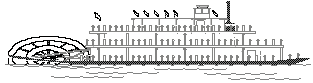
Steamboats steamed up and down the lake bringing in great cargoes of sugar,
meat, flour, syrup and merchandise, furniture, wagons, buggies and plows. The big
sidewheeler "The Morning Light" was frequently seen steaming down the bayou with
as many as three thousand bales of cotton destined for New Orleans. Others seen often on
the lake included the cargo boats, "Weswing", "Wheel of
Fortune" and "Blue Wing", cargo and passenger boat, "Danube", the
freighter "Rosa Bland", sternwheelers "Bonita" and "Bill
Butler",and other unspecified types "Jewell", "Marie Louise",
"Alexandria", "Shamrock", and "Moonstone"(see 1880). Many a party was given on
board while the cargoes were unloaded and then reloaded with cotton.
Click Here to read excerpts from an article written
by Rita Moore Krouse.
1833- Captain Henry Miller Shreve started
the removal of the Great Raft that took almost 40 years to complete. By 1938 Shreve had
forced a channel through the Raft but the Raft began to reform less than three months
later. Additional clearing was made in 1841 but by the beginning of the Civil War the Raft
had reformed. After the Raft's final removal in 1873, it took 20 years for the Red River channel near Shreveport to drop 15 feet.
1833 was also the year of the "Bear
Fight on Dorcheat".. The story goes, that two men named Alexander and Masters set out
to kill an old bear that had been taking their hogs in Bayou Dorcheat swamp. They soon
came upon the bear and the chase began. Alexander took his stand in a slough awaiting the
bear. When the bear spied Alexander and made for him, Alexander's gun misfired and had it
not been for his buckskin suit, he would have surely been killed. Alexander was, however,
maimed for life.
1835- The Caddoan Treaty Of 1835 removed the
few remaining Caddo Indians from the area. Most other Indian peoples eventually moved away
or were greatly reduced by war, disease or intermarriage. The Coushatta and Choctaw were
the only remaining Indian communities in the area.
This was also the year that Minden was established by C.H.Veeder. Overton was
also established the same year and named for Judge J.H.Overton who outlived the town. Both
towns began immediately to compete for the Parish Site since a division of Claborne was
much talked about. However, this division did not materialize but the courthouse for
Claiborne was moved from Russellville to Overton.
1837 - Captain Shreve had broken thru the
logjam in Red River enough to allow some boat traffic north from Natchitoches and the city
of Shreveport was born. With this also came the"beginning of the end" for the
great steamboat days on Lake Bistineau. For more about the Red River then and today click
on Red River Waterway.
1843- Bossier Parish was created from the
Claborne Parish territory. Bienville was to be next in 1848.
1846-
By this time Overton had proved to be unhealthy and subject to overflows, and
the population having become preponderant in the eastern portion of the parish,
caused the parish seat to be moved to Athens. It remained in Athens until the
court house burned destroying all the records. In 1849 the first District Court
was held in its new location, where Homer stands today.
1848- Bienville Parish was created by
dividing the remaining territory in Claborne Parish through the middle east to west. Homer
was designated Parish Site for Claborne and Sparta for Bienville. Webster was next to be
established in 1871.
1850-As steamboat traffic continued to grow,
occasionally a boat would strike a stump or fire would break out sometimes ending in
disaster. "The Shamrock", one of the earliest boats to ply the lake trade, was
loaded with cotton and on its journey down the lake near Augusta Point below Noles Landing
when fire broke out and it burned and sank. Another boat sank near Pine Bluff
Landing(Laguna Beach) after hitting a stump. Up Dorcheat near the old highway 80 bridge is
the site of another wreck. One boat, loaded with mules, was docking at Lower Landing when
the mules became frightened and jumped into the bayou and drowned.
1850 also brought the beginning of
commercial salt production to Lake Bistineau(by the Hodges brothers). A salt spring
located near the head of Lake Bistineau is known as the Bistineau Salt Works and was the
location of a salt production site for the Late Caddo Indians as well as for the
Confederacy during the Civil War.The salt evaporated from the brine water was mostly sold
locally and during 1855-56 when drought lowered water levels preventing import of salt
from other sources production at the Lake sites was expanded. During the Civil War when
all imports to the area were ceased there were several large enterprises operating,
employing up to 1,500 people in the salt-making process.The Lake Bistineau operations
became the second largest operation in the state but, when the war ended so did serious
salt production at Lake Bistineau.
1854-
Minden was incorporated.
1857-The development of a trail running
east-west from present-day Monroe to Shreveport began in the 1820s and eventually became a
wagon road, then a stage route, and finally the route for telegraph wires in the 1850s.
This trail roughly parralled todays US Highway 80 where the original Dixie Inn highway
bridge was constructed across Bayou Dorcheat just north of Overton in 1857.
1861-
From 1850 to 1861, the accumulation of property in this area was immense,
churches were established everywhere; schools in every neighborhood; prosperity
blessed the land and the people were just plain happy. But the war clouds came
down in 1861 and with them the present and promising future vanished in the
turmoil and devastation of competing armies.
1862- R. Thomassy, a French geologist, came
to Lake Bistineau and began to make salt at Tadpole Slough, constructing a salt storage
house on the east end of Frenchman's Island which still bears that name in his honor.
1869-
During the war years the wild animals of this area increased rapidly because
there were no hunters left at home to hunt them down. After the war ended and
men returned home, the population of wild game was quickly reduced as hunting
for food and sport resumed. The last panther was killed near Mount Lebanon in
1869, by P J Key, and the last bear about 8 years later, by W J King.
"Memoirs of NW La 1976"
1871- Webster Parish was created in Feb 1871
with the Parish Site at Minden. The parish was fiscally healthy with Cotton Valley,
Murrell's Point, Shongaloo, Taylors Store and Germantown providing small business centers.
The Minden landings, Murrell's Point, Noles Landing and Port Boliver were principal
shipping points on the lake and bayou. Between 12,000 and 15,000 bales of cotton were
being shipped yearly from Minden landings and about twice that quantity from the Lake
Bistineau landings.
1872- A fire
on December 30, 1872, resulted in the destruction of the business center of
Minden.
1873- The greatest days for the steamboats
on the lake lasted through the Civil War but the death of steamboats on the lake, though
long in coming, began in 1833 when Henry Miller Shreve started clearing out the logs,
vines and silt that, since the 1400s, made up the "Great Raft" on Red River.
Clearing efforts continued on the 180 mile long raft until 1873 when,only due to
the availability of nitroglycerine to blow it apart, it was finally cleared completely.
Meanwhile, with the river flowing more freely each year as the river was being cleared and
less backwaters to overflow and feed the lake, gradually and imperceptible at first, the
level of Bistineau began sinking.
1880- After traveling from
New Orleans up the Mississippi and Red rivers, through Lake Bistineau and up Bayou
Dorcheat to Murrells Point, the Freighter "Moonstone" was considered unable to
return with it's planned cargo of cotton. This freighter was one of the last such vessels
to make the long journey into the Dorcheat landings. After being abandoned for its
intended use, the boat was salvaged and its usable lumber was used to erect a cotton gin
and grist mill a few yards below the Dixie Inn bridge. The boiler and engine was used to
operate the mills for well over 20 years before being moved to the Beech Springs community
to operate a saw mill. The boiler was finally abandoned in 1912 and could be seen near the
Beech Springs Church. Over 50 years after being abandoned, the hull from the sunken
freighter could still be seen just below the Dixie Inn bridge during periods of low water.
1884
-A midnight fire of January 18-19, at Murrell's Point destroyed 1,145 bales of
cotton belonging several prominent business men and resident planters.
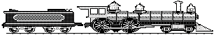
The "Vicksburg Shreveport &
Pacific Railroad" was completed in 1884 between Monroe and Shreveport crossing Bayou
Dorcheat adjacent to the present day Sibley/Doyline road. To allow continued boat
traffic up and down the bayou. The bridge built across Dorcheat, called a "Swing Span
Bridge", was designed to turn on a center pier providing 59 feet of clearance on
either side of the center pier, 21 feet of vertical clearance above low water and 5 feet
of clearance above high water line. Like similar bridges built during that timeframe,
manual labor was used to turn it. Using a large wheel that would be temporarly attached to
a vertical shaft fixed to gears located in the center of the bridge, several men would
turn the wheel causing the tracks to turn.
This Swing Span bridge still provides rail crossing over the bayou today, but has not been
required to turn for boat traffic since 1888/89 when the Sibley/Doyline road bridge was
built, essentially blocking large boat passage. Earl Smith of Sibley recalls hid Dad
telling him that the bridge was turned only once after it was built. That one time used
was to allow a gravel boat pass. Following construction of this fixed road bridge, the
"Minden East & West Railway" built in 1907/08, just north of present day
I-20, also used a fixed bridge.
Since the Vicksburg Shreveport & Pacific line was the first railroad in Webster
Parish, that makes the Dorcheat Bridge a significant historical landmark as the first
railroad bridge in the parish.
1885 -With the completion of the Vicksburg
Shreveport & Pacific Railroad, the Lake Bistineau area soon became a hub for other
rail links. The first being the Minden Tap. Minden, the seat of Webster Parish,
recognizing the importance of the railroad that by-passed the town 5 miles south, quickly
chartered the Minden Railroad and Compress Co. to build a 5-mile rail line between Minden
and the VS&P at Lanesville. The little railroad was completed in November 1885 and was
known as the Minden Tap. Lanesville was soon renamed Sibley (see 1804). The Minden Tap was
later extended further north, see 1898.
1888- The first bridge was built near
Doyline stopping all large boats from navigating further upstream, even during the high
waters of spring. The channel of Lake Bistineau had cut itself so deep from the rapid
current of the River overflow that after removal of the Great Raft the Lake
drained itself and only contained water during the spring. Navigation through the lake for
steamboats was limited to January or February through the spring months because for five
or six months beginning in summer and extending through the autumn season the greater part
of the lake bed was uncovered, the waters receding and draining off into Red River.
It was at this time
that a new kind of grass began to grow upon the lake bed immediately following the annual
subsidence of its waters. The grass grew to a height of two or more feet and so thick that
it choked out and destroyed the cocklebur and other weeds and grasses. It was an excellent
forage grass and cattle from all living within convenient distance were driven to graze
and fatten upon it. It was soon discovered that hay made from it was better than the best
market afforded. The result was that the local farmers began cutting and bailing the hay,
both for their own use and for market. This practice took place every growing season when
the lake bed was uncovered of water and the grass grew abundantly until 1896 when a dispute arose on access and
ownership of the hay fields or "Hay Meadows" as our current lake maps refer.
1890-
One of the most important industrial breakthroughs for Minden came with the
invention of the Cotton Compress. No sooner was it completed than the old town,
which lagged for a time, resumed great activity. Minden was the home of the Webb
Cotton Compress as well as the A S Harrell cotton chopper, both giving great
progress to the area.
1891- What soon grew into one of the largest
and most unique sawmill towns in the State was established in 1891, when Mssrs. Allen
Bros. & Watley, saw mill men bought several acres of land near what is now LAAP. Click
here for the story of Allentown and the Allen Bros. &
Watley Ltd. Sawmill.
1892- The ending of the steamboat era on
Lake Bistineau caused by the clearing of Red River and the coming of the railroads saw
only two or three trips a year and only then during high water. The last freighter to come
up lake was the "Rosa Bland" and it only came as far as Noles Landing. In 1892
the only road between Shreveport and Dorcheat was closed for repairs and travelers going
east were carried by the "Blue Wing" down the Red to Loggy Bayou then up through
Lake Bistineau to the V.S.and P Railroad crossing on Dorcheat where they were unloaded and
entrained for all points east. This marked the last of the steamboat travels on the lake
and sealed the death of the once thriving Lake Bistineau communities that had formed the
first center of commerce and culture in NW Louisiana.
1892
also brought an end to the last, although very small scale, salt production at Lake
Bistineau.
1896-
This was the year of the "Terrible Drought in North Louisiana". From
May to December, no rain fell and temperatures turned savagely hot with
108-degrees marking the first day of August. Thirsty rattlesnakes crawled into
peoples yards. In Webster Parish, Dorcheat Bayou went dry and rain prayers were
held on its banks.
Approximately 220 acres of land
bordering the lake adjacent to the Hay Meadows, that grew the much sought after grass(see 1888), was purchased by L.R.Sapp where he
believed that by acquiring the lands fronting on the lake, he would take proprietorship to
the center of the lake bed. Having purchased and taken possession, he announced his
purpose to claim the right of ownership and of dominion to and over the lake bed in front
of his holdings. Two local farmers, Frazier and Noles, who lived near by and had been
cutting grass there for several years were again preparing to harvest the grass. They were
on the ground with bailing press, mowers, etc., and had cleared away the bushes, erected a
small cabin for shelter and cut some hay when Sapp appeared, claimed the ground and the
grass, forbade further cutting and after having one of them arrested for trespassing, then
brought action to restrain them by writ of injunction from going upon that part of the
lake bed or cutting grass there.
This dispute was not
settled until 1899 when the Supreme Court of Louisiana hearing an appeal from the Judicial
District Court of Webster; J.T.Watkins, Judge, ruled that no one can take such possession
of the lake bed, or any part of it, for such purpose, so as to exclude others from
it, and the lake and lake bed are free to all to enter upon it, for any purpose not
unlawful, and no one may claim any privilege there superior to others. As the situation
is, the lake bed is a public place, open to the legitimate use of all alike. The
harvest of the grass resumed only until the dam was built and the lake no longer
emptied it waters annually.
1898 - Rails connecting the Lake Bistineau
area to towns further north were soon laid. In July 1898, the Minden Tap was sold to the
new Arkansas Louisiana & Southern railroad and extended northward. In September 1898
the AL&S reached Cotton Valley and connected with the Louisiana & Arkansas
Railroad, forming a route to Hope and Stamps,Arkansas. The Sibley hub was growing bigtime.
1899 - The "Sibley, Lake Bistineau
& Southern Railway" was built in 1899 by the Long-Bell Lumber Co. of Kansas City
to connect their mill at Yellow Pine with their timber lands to the south and with the big
railroads at Sibley. The SLB&S ran south from Sibley 28 miles to Camp Long (just about
a mile past Hall Summit).It's stops were: mile 0--Sibley, mile 3--Gravel Spur, mile
6--Yellow Pine, mile 11--Martin Junction(present day intersection on Hwy 371 near
Bistineau Baptist Church), mile 13--Davis, mile 16--Ringgold, mile 22--Giddens, mile
25--Madden's Spur, mile 27--Halls Summit and mile 28--Camp Long. Click here for more
info about Yellow Pine Community.
The line was built
primarily for hauling timber,however, according to longtime Sibley residents, Danny
Hillidge and Earl Smith, it was also used to carry passengers as well as cotton up to
Sibley where the freight cars were transferred onto the VS&P for shipment to other
terminals or to final destinations. The train made one run per day... it left Yellow Pine
at 6:15am and arrived at Sibley at 7:00. Then it left Sibley at 7:45, arrived at Camp Long
at 10:40, left Camp Long at 11:00 and arrived back at Yellow Pine at noon, where it
remained until the next morning. Danny recalls the line running near his home and
the turntable used to turn the engines around was located just behind his parents house.
Earl also recalls the
mailcar that rode the rails to and from Hall Summit twice daily. This was not part of the
train used for shipping but an individual vehicle with special wheels that allowed it to
ride on the tracks. Earl recalls one incident when he was very young, that a large pig
attempting to avoid slaughter escaped from its owner and ran into the mailcar, knocking it
off the tracks.
The scheduled stops
changed in 1937 after passenger service had been discontinued. The stops from 1937 to 1942
were: mile 0--Sibley, mile 4.5--Yellow Pine, mile 7,5--Bistineau, mile 10.0--Martin
Junction, mile 12--Davis, mile 13.5--Thomas, mile 16.5--Ringgold, mile 20.5--Tullis, mile
21.5--Giddens, mile 27.1-- Halls Summit.The railroad was abandoned in 1942 and the steel
rails were immediately taken up and likely used to support the War efforts.
The VS&P was not
the only railroad interested in expanding service the Sibley hub. In 1899 the Louisiana
& Arkansas Railroad began building south from Sibley. The L&A bought the AL&S
in 1900 and was completed to Alexandria in 1906. Sibley was now a major hub for rails
traffic.